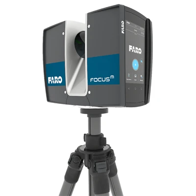
Model: Traceable 3D Laser Scanner
In the last few decades, 3D reality capture has become the preferred method of capturing the as-built condition of any physical asset. Millions of bits of data are converted into 3D point clouds, creating an accurate virtual representation of what was scanned. If you are looking for you may explore now here the Traceable 3D Laser Scanner Price in Bangladesh.
But even a modest project can generate hundreds, perhaps thousands of scans, each one requiring point cloud registration. Not only must scans be taken, registered and aligned the first time, but throughout an asset’s lifecycle. It’s in exactly these situations repeat scanning and repeat alignment where target-less or cloud-to-cloud registration can run into challenges.
Traceable 3D de-silos data and brings it into a single compatible coordinate system through target-based scanning with specialized mounted targets. It provides a fixed, but re-locatable, anchor point, enabling repeatable scan alignment and ensuring that even the most minute changes in a physical asset are captured.
High detail targeted scanning when cloud-to-cloud isn’t enough
Target-based scanning takes target-less scanning to the next level of precision and accuracy. That’s because even with extremely close scan positions and breaking the scans into many clusters, cloud-to-cloud registration struggles with geo-referencing and with very large projects. Traceable 3D goes further still and allows operators to put down targets and take multiple scans of a given location and use them to register the point clouds accurately with the ability to repeatedly update the data.
This is especially true when working with survey control and aligning scans to a known coordinate system such as tunneling or in industrial plants like automotive and manufacturing where it’s difficult to perfectly overlap scans and where small gaps in the data make the modeling process more complex. Likewise, the same challenges arise when scanning physical assets with repetitive features including long hallways, stairways, parking garages and concrete pipes, along with boiler rooms or utility rooms where conduits and other elements disrupt the space.
By employing targeted scanning/surveying versus target-less scanning, professionals with project oversight and equipment upkeep responsibilities, will have greater confidence in the accuracy of their builds. This is ideal for documenting how physical assets evolve and change over time and for geo referencing that data in a universal coordinate system that’s sharable with a variety of precision measurement tools. Traceable 3D and its suite of target accessories and tools, including hardware and software, guarantees project fidelity, over time by establishing repeatable benchmarks that support data capture and analysis in a traceable and reusable process.
Business Value
Save time and improve productivity
The technology works with all types of surveying, scanning and metrology equipment. As the need for 3D scanning increases, users can position reference points and update the point cloud as each new scan comes in, documenting even the smallest changes in design layout. This speed and accuracy provides project stakeholders a better overview of the project at hand as changes are implemented. Data from the fieldwork is digitally processed, analyzed and generates new points to be set out. As the project evolves and new information becomes available, this data is digitally processed, analyzed and synchronized.
High accuracy, repeatable scans
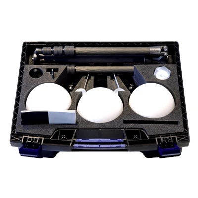
The Traceable 3D Reference System features a suite of target accessories and tools that enable high accuracy, repeatable scans, ideal for large, complex projects and assets with narrow connections or situations with poor scan overlap (like stairwells or structures with repetitive patterns). Highlights include a unique target mount that is easily and permanently installed for projects and provides a benchmark for repeat scans with high accuracy. Other accessories, like a prism, can be magnetically mounted to this washer to add flexibility to a scanning project.
Multimodal use
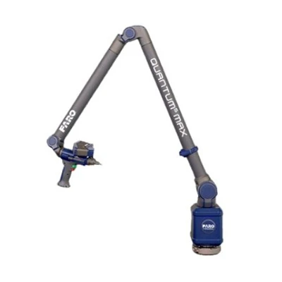
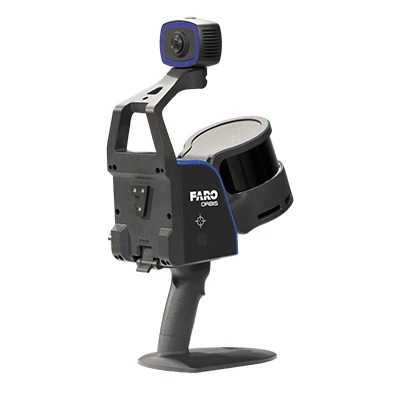
The Faro Traceable 3D Reference System isn’t just for 3D laser scanners. With repeatable, accurate, interference eliminating mounts and target mount, the data acquired from targeted scanning is swappable for use with a variety of laser measurement tools, including laser projectors for tracing, measuring large, heavy, physical templates, trackers for measuring large parts, molds, assemblies and machines, portable measurement arms in combination with a tracker device, and total stations.
Reusable data, incrementally updated
Data universality means all targeted data points are collected in the same coordinate system. The data can be used, shared and referenced repeatedly, even as both a building’s exterior and interior change over time, with whatever combination of devices you’re measuring with.
Georeferenced data to grid or map
Georeferencing is the process of taking a digital image, scanned or otherwise, and adding geographic information to the image so that GIS or mapping software can match the image to its actual physical location on earth. With Traceable 3D, mounted rectangular or spherical targets serve as the geo located data reference points and adds accuracy and precision to
Key Features: Traceable 3D Laser Scanner
A Complete 3D Reference System
Traceable 3D accessories are standardized for interchangeability and calibrated to FARO’s exacting standards. Over thirty-five new items have been added to the company’s suite of targeted scanning products, including large and medium-sized spheres and flat targets, as well as precision target mounts, tripod quick releases and magnetic mounts for temporary mounting on flat and convex steel surfaces.
Expert Support
Traceable 3D experts are available to support detailed questions about targeted 3D reality capture devices and help with recommendations regarding toolkits and pricing.
Calibration and Accuracy Guaranteed
Calibrated and traceable targets assure quality with 1mm proved system accuracy on all targets, ensuring verifiable reusable data at any time. Data is generated in an entirely structured manner, easily sharable and exportable to other systems and various project stakeholders.
Connectivity to Multiple Measurement Systems
The technology is designed to work with all types of surveying, scanning and metrology equipment — any scenario where targetless data capture would prove difficult or imprecise.


 Calibration
 HVAC/Clean Rooms
 Electrical
 Temperature Meters
 Power & Energy
 Mechanical & Maintenance
 Pharma, Health & Biomedical
 Drone Solution
 Networking
 Transformer & Relay Testing
 Insulation, Resistance and Battery
 Fault Testing & Diagnostics
 Lightning Protection Solution
 Education, Research & Development
 Civil Equipment
 Renewable Energy
 Cleaning and supplies
 Power Tools
 Safety Tools
 Hardwares
 Construction Supply
 Stationeries
 Garden Tools
 Accessories
 Machines
 Hand Tools