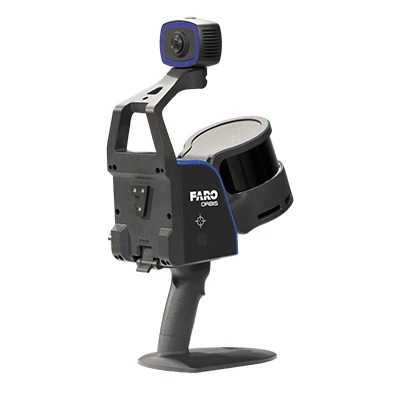
Model: FARO Orbis Mobile Laser Scanner
FARO® Orbis™ range are unique mobile scanning solutions created to optimize workflows and elevate productivity. Designed for surveying and mapping, engineering, and construction, and public safety professionals, Orbis delivers rapid speed of capture, while returning highly accurate 3D visual representations of the real world. Integrating FARO’s Flash Technology™ in Orbis allows for stationary scans in approximately 15 seconds and provides excellent detail from a mobile mapping solution.
Orbis Premium elevates mobile scanning with a new, powerful camera and an IP54 rating for rugged conditions, capturing vivid and quality images for point cloud colorization. It’s the ideal solution for professionals needing accuracy and resilience in any environment.
Powered by GeoSLAM’s proven SLAM algorithm, Orbis and Orbis Premium are the next steps for industry professionals looking to quickly deliver highly accurate results, reduce user impact, and increase overall efficiency. Leverage the power of Flash Technology™ scanning capabilities elevated by in-field cloud-connectivity with FARO Sphere® XG and embark on a new journey to transform your projects with Orbis and Orbis Premium, the ultimate companions for modern scanning challenges.
Business Value of FARO Orbis
Flash Technology™ and 72MP Camera Quality
Improve your mobile scanning quality with Flash Technology™. Previously unseen in a mobile scanning solution, Orbis and Orbis Premium offer mobile scanning and stationary scanning capabilities with Flash, delivering high quality, accurate, and dense datasets. These Flash scans are embedded in the overall SLAM point cloud and could be created as often as needed in a project. It’s a combination of speed, data clarity and accuracy in one complete scanning solution.
10x Faster Than Other Surveying Methods
Experience unmatched speed of data capture with mobile scanning technology. Designed for rapid deployment, Orbis and Orbis Premium ensure fast and accurate data acquisition, revolutionizing your project timelines. It empowers users to capture detailed and accurate spatial data 10x faster than traditional laser scanning, accelerating workflows and ensuring you stay ahead in today’s fast-paced world.
Frequent Data Capture for Better Insights
Capture 3D data more frequently and comprehensively than ever before and elevate your data insights. Stay up to date with fast-paced and evolving scenarios to enhance decision-making and improve collaboration. Ease of use, cloud connectivity to Sphere XG, and portability make frequent and fast data capture possible — a constant stream of fresh insights to transform your projects or quicker turnarounds in sensitive areas like public safety sites.
Scanning Doesn’t Need to be Complicated
Designed with usability in mind, scanning with Orbis or Orbis Premium is as simple as pushing a button and walking with the device. It simplifies complex surveying tasks, enabling efficient data collection for a broader audience, across various industries. Unlike other scanning methods, minimal training is required to get going with the scanner. The ease of use expands the opportunities for data capture in previously unobtainable or sensitive places.
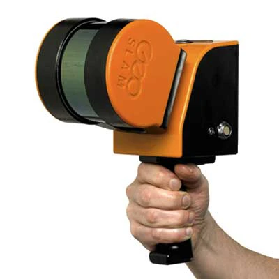
The World’s Leading SLAM Algorithm
A proprietary SLAM algorithm drives Orbis and Orbis Premium and has been tried and tested in some of the most difficult environments, for over a decade. Constant innovation from customer input has led to the SLAM algorithm that continues to deliver and improve customer projects, in a myriad of industries.
Key Features: FARO Orbis Mobile Laser Scanner
FARO Orbis Features
Lightweight and Easy-to-Use
Weighing 3.6kg (7.93lbs) in total, including datalogger and battery — with the scanner weighing just 2.1kg and the datalogger 1.5kg — Orbis is ideal for scanning large areas fast, without large setups.
Higher Levels of Accuracy
A precision of up to 5mm during a mobile scan and up to 2mm during stationary Flash scanning makes Orbis the ultimate mobile scanning solution for high levels of accuracy.
Ideal for Internal and External Mapping
With up to 120 meters in range, Orbis is the ideal solution for both indoor and outdoor scanning, with the ability to seamlessly transition between both.
Best of Both Worlds Processing
Orbis offers local offline processing in the FARO Connect software or optional cloud-based processing in Sphere XG – flexible solutions for processing, analyzing and sharing sensitive data.
360° Photos and Colorized Data
The integrated high-resolution camera on the Orbis Premium enables colorized point clouds and additional 360° panoramic pictures.
Engineered for the Toughest Environments
Engineered with the toughest environments in mind, Orbis can easily map places like underground mines, dense forests, crash/crime/fire scenes, or construction sites. Furthermore, it can scan in complete darkness for areas with limited or no lighting.*
The All-in-one Mapping Solution
The Orbis is compatible with a monopod for stationary Flash scanning, car mount for capturing larger areas, backpack for tough terrain, and cradle for descending into vertical shafts or dangerous areas like post-disaster incidents - it is truly an all-in-one solution.
*Colorized point clouds will be impacted by areas captured in darkness or dimly lit areas
Merge Point Clouds, Sync Libraries
Register and merge two different scans in Sphere XG into one project point cloud. Ensure an overlap of scanned areas, align, and unify large captures on a single sheet. The 2-way synchronization between FARO Connect and Sphere XG enables you to keep data updated and leverage the advanced viewing options and accessibility of both platforms to create detailed point cloud data.
Improved Camera
The Orbis Premium’s upgraded 72MP camera brings an entirely new level of clarity to mobile scanning, delivering vibrant, high-resolution panoramic images and colorized point clouds. This enhancement helps users capture intricate details and visualize data with greater realism, making complex projects easier to interpret and analyze.
IP54 Rating
With its IP54 rating, Orbis Premium is built to withstand challenging conditions. This durability ensures consistent performance in rugged environments, giving professionals confidence in reliable, accurate data capture no matter where their work takes them.
Improved Data Handling: Enhanced Reliability with Orbis Premium’s Advanced Data Logger
The Orbis Premium features enhanced reliability and processing within its data logger, ensuring smoother, more efficient data handling in real time. This upgrade means faster workflows and more dependable results.
Accessories: FARO Orbis Mobile Laser Scanner
Backpack
Attach the Orbis Premium to our ergonomic backpack mount to go hands-free and capture high-quality spatial data on the move. Built for comfort and stability, it makes scanning large outdoor areas and challenging terrain effortless.
Car Mount
Transform any vehicle into an efficient data collection platform with our robust Orbis Premium car mount. Designed for stability and easy installation, it offers a secure base for the mobile scanner, allowing for quicker geospatial mapping of larger areas.


 Calibration
 HVAC/Clean Rooms
 Electrical
 Temperature Meters
 Power & Energy
 Mechanical & Maintenance
 Pharma, Health & Biomedical
 Drone Solution
 Networking
 Transformer & Relay Testing
 Insulation, Resistance and Battery
 Fault Testing & Diagnostics
 Lightning Protection Solution
 Education, Research & Development
 Civil Equipment
 Renewable Energy
 Cleaning and supplies
 Power Tools
 Safety Tools
 Hardwares
 Construction Supply
 Stationeries
 Garden Tools
 Accessories
 Machines
 Hand Tools