DJI P4 Multispectral:
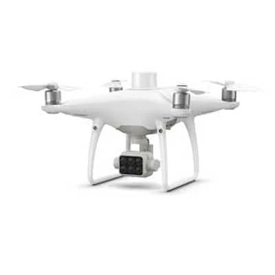
The DJI Phantom 4 Multispectral is a specialized drone designed for agricultural and environmental monitoring applications. It features a multispectral camera that captures high-resolution RGB images along with data from five different spectral bands, allowing users to analyze vegetation health, crop vitality, and land use. The drone is equipped with a precision GNSS module for accurate geotagging of images, facilitating detailed mapping and analysis.
With a flight time of up to 27 minutes, the Phantom 4 Multispectral enables efficient surveying over large areas. Its user-friendly interface and intelligent flight modes make it accessible for both professionals and researchers. The drone's robust design ensures stability and reliability during flight, making it an excellent choice for precision agriculture, environmental assessments, and forestry applications.
If you’re searching for the best price on DJI Enterprise drones in Bangladesh, look no further! Tools Bangladesh offers exceptional value with high-end features and capabilities. Elevate your farming efficiency with our advanced drones designed to meet your needs.
Key Features:
- Multispectral
- Imaging System
- Live NDVI View
- RTK Module
- TimeSync
Specifications:
Aircraft
-
Max Flight Time
-
Approx. 27 minutes
-
Image Position Compensation
-
The relative positions of the centers of the six cameras’ CMOS and the phase center of the onboard D-RTK antenna have been calibrated and are recorded in the EXIF data of each image.
Mapping Functions
-
Ground Sample Distance (GSD)
-
(H/18.9) cm/pixel, H indicates the aircraft altitude relative to the area mapped (unit: m)
-
Rate of Data Collection
-
Max operating area of approx. 0.63 km2 for a single flight at an altitude of 180 m, i.e., GSD is approx. 9.52 cm/pixel, with a forward overlap rate of 80% and a side overlap ratio of 60%, during a flight that drains the battery from 100% to 30%.
GNSS
-
Multi-Frequency Multi-System High-Precision RTK GNSS
-
Frequency Used
GPS: L1/L2; GLONASS: L1/L2; BeiDou: B1/B2; Galileo[2]: E1/E5
First-Fixed Time: < 50 s
Positioning Accuracy: Vertical 1.5 cm + 1 ppm (RMS); Horizontal 1 cm + 1 ppm (RMS).
1 ppm indicates error with a 1 mm increase over 1 km of movement.
Velocity Accuracy: 0.03 m/s
Gimbal
-
Controllable Range
-
Tilt: -90° to +30°
Vision System
-
Altitude Range
-
0 - 33 ft (0 - 10 m)
-
Operating Range
-
0 - 33 ft (0 - 10 m)
-
Obstacle Sensory Range
-
2 - 98 ft (0.7 - 30 m)
Camera
-
RGB Sensor ISO Range
-
200 - 800
-
Monochrome Sensor Gain
-
1 - 8x
-
Max Image Size
-
1600×1300 (4:3.25)
Remote Controller
-
Max Transmission Distance
-
FCC / NCC: 4.3 mi (7 km)
CE / MIC / KCC / SRRC: 3.1 mi (5 km)(Unobstructed, free of interference)
-
Built-in Battery
-
6000 mAh LiPo 2S
-
Mobile Device Holder
-
Tablets and smartphones
Intelligent Flight Battery (PH4-5870mAh-15.2V)
Intelligent Flight Battery Charging Hub (PHANTOM 4 CHARGING HUB)
AC Power Adapter (PH4C160)


































 Calibration
 HVAC/Clean Rooms
 Electrical
 Temperature Meters
 Power & Energy
 Mechanical & Maintenance
 Pharma, Health & Biomedical
 Drone Solution
 Networking
 Transformer & Relay Testing
 Insulation, Resistance and Battery
 Fault Testing & Diagnostics
 Lightning Protection Solution
 Education, Research & Development
 Civil Equipment
 Renewable Energy
 Cleaning and supplies
 Power Tools
 Safety Tools
 Hardwares
 Construction Supply
 Precision Tools
 Garden Tools
 Accessories
 Machines
 Hand Tools